![](/images/other/stat-length.png)
![Tocht Stappen Δημοτική Ενότητα Θήρας - Imerovigli à Oia - Photo](https://media.geolcdn.com/t/1900/400/ext.pjpeg?maxdim=2&url=https%3A%2F%2Fstatic1.geolcdn.com%2Fsiteimages%2Fupload%2Ffiles%2F1553511878bg_sport_marche.png)
Imerovigli à Oia
dawed311
Gebruiker
![Lengte](/images/other/stat-length.png)
![Max. hoogte](https://static1.geolcdn.com/siteimages/upload/files/1508320355ic_sort_altitude_max_24dp.png)
![Positief hoogteverschil](https://static1.geolcdn.com/siteimages/upload/files/1508320355ic_sort_den_pos_24dp.png)
![Km-Effort](/images/other/stat-length.png)
![Min. hoogte](https://static1.geolcdn.com/siteimages/upload/files/1508320355ic_sort_altitude_min_24dp.png)
![Negatief hoogteverschil](https://static1.geolcdn.com/siteimages/upload/files/1508320355ic_sort_den_neg_24dp.png)
![Boucle](https://static1.geolcdn.com/siteimages/upload/files/16400158638029165_repeat_loop_refresh_sync_direction_icon.png)
![Stappen](https://static1.geolcdn.com/sitytour/trail-icons/101.png)
2h24
Moeilijkheid : Gemakkelijk
![Scan deze QR-code om de tocht te openen in de SityTrail-applicatie](https://capi.geolives.com/qq0zvz2zws4bq2lad0pu/sitytour/trails/3647633/qr.png?size=200)
Gratisgps-wandelapplicatie
Over ons
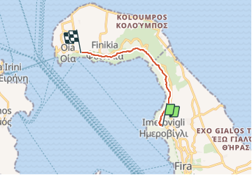
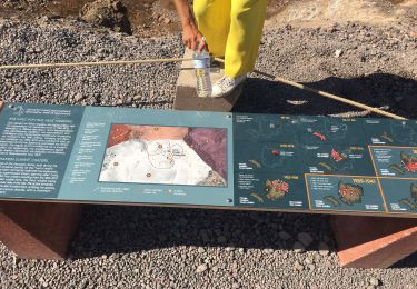
Tocht Stappen van 8,1 km beschikbaar op Egeïsche Eilanden, Περιφερειακή Ενότητα Θήρας, Δημοτική Ενότητα Θήρας. Deze tocht wordt voorgesteld door dawed311.
Beschrijving
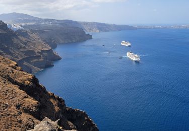
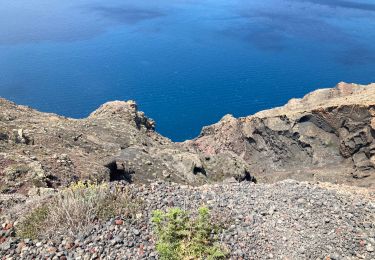
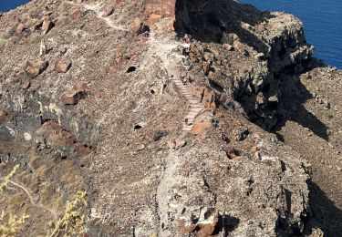
Randonnée sur le haut de la caldeira de Santorin.
Magnifique randonnée faite en famille, sans aucun danger.
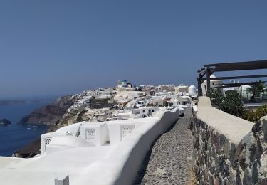
Ne pas oublier d'aller visiter le rocher de Skaros, notamment au coucher du soleil, bien moins fréquenté qu'Oia et tout aussi beau.
Plaatsbepaling
Opmerkingen
Wandeltochten in de omgeving
![Tocht Stappen Δημοτική Ενότητα Θήρας - Santorin - Fira - Oia - GRECE - Photo](https://media.geolcdn.com/t/375/260/265a4e14-44f8-4a97-b693-7bd5f41e3eab.jpg&format=jpg&maxdim=2)
![Stappen Stappen](https://static1.geolcdn.com/sitytour/trail-icons/101.png)
Stappen
![](/images/other/stat-length.png)
![](https://static1.geolcdn.com/siteimages/upload/files/16400158638029165_repeat_loop_refresh_sync_direction_icon.png)
![Tocht Stappen Δημοτική Ενότητα Οίας - Finikia-Imerovigli-Finikia - Photo](https://media.geolcdn.com/t/375/260/528a81f6-3e8b-4dab-bd62-47c0bdf8c508.jpg&format=jpg&maxdim=2)
![Stappen Stappen](https://static1.geolcdn.com/sitytour/trail-icons/101.png)
Stappen
![](/images/other/stat-length.png)
![](https://static1.geolcdn.com/siteimages/upload/files/16400158638029165_repeat_loop_refresh_sync_direction_icon.png)
![Tocht Stappen Δημοτική Ενότητα Θήρας - Balade Fira Ioa avec pique nique - Photo](https://media.geolcdn.com/t/375/260/c362c7e7-7199-479d-86bf-9e211b7178f6.jpg&format=jpg&maxdim=2)
![Stappen Stappen](https://static1.geolcdn.com/sitytour/trail-icons/101.png)
Stappen
![](/images/other/stat-length.png)
![](https://static1.geolcdn.com/siteimages/upload/files/16400158638029165_repeat_loop_refresh_sync_direction_icon.png)
![Tocht Stappen Δημοτική Ενότητα Θήρας - Nea Cameni - Photo](https://media.geolcdn.com/t/375/260/8fd492d4-415a-41b9-8e6f-012adc4855ff.jpg&format=jpg&maxdim=2)
![Stappen Stappen](https://static1.geolcdn.com/sitytour/trail-icons/101.png)
Stappen
![](/images/other/stat-length.png)
![](https://static1.geolcdn.com/siteimages/upload/files/16400158638029165_repeat_loop_refresh_sync_direction_icon.png)
![Tocht Stappen Δημοτική Ενότητα Θήρας - Santorin le 26-09-19 - Photo](https://media.geolcdn.com/t/375/260/50f2c084-2b19-477f-91a1-8a4c21b721d0.jpg&format=jpg&maxdim=2)
![Stappen Stappen](https://static1.geolcdn.com/sitytour/trail-icons/101.png)
Stappen
![](/images/other/stat-length.png)
![](https://static1.geolcdn.com/siteimages/upload/files/16400158638029165_repeat_loop_refresh_sync_direction_icon.png)
![Tocht sport Δημοτική Ενότητα Θήρας - Fira>>oiya - Photo](https://media.geolcdn.com/t/375/260/02bd5263-412a-4b5c-ae85-56f5d9cdb805.jpg&format=jpg&maxdim=2)
sport
![](/images/other/stat-length.png)
![](https://static1.geolcdn.com/siteimages/upload/files/16400158638029165_repeat_loop_refresh_sync_direction_icon.png)
![Tocht Stappen Δημοτική Ενότητα Θήρας - Fira a lia a santorin - Photo](https://media.geolcdn.com/t/375/260/4f844e7a-fbeb-4d8f-b4de-486bc0cb0b9b.jpg&format=jpg&maxdim=2)
![Stappen Stappen](https://static1.geolcdn.com/sitytour/trail-icons/101.png)
Stappen
![](/images/other/stat-length.png)
![](https://static1.geolcdn.com/siteimages/upload/files/16400158638029165_repeat_loop_refresh_sync_direction_icon.png)
![Tocht Motorboot Δημοτική Ενότητα Θήρας - Santorin volcan central - Photo](https://media.geolcdn.com/t/375/260/ext.jpg?maxdim=2&url=https%3A%2F%2Fsecurestorage.geolives.com%2Fsitytour%2Ftrail-bg%2Fdefault.jpg)
![Motorboot Motorboot](https://static1.geolcdn.com/sitytour/trail-icons/701.png)
Motorboot
![](/images/other/stat-length.png)
![](https://static1.geolcdn.com/siteimages/upload/files/16400158638029165_repeat_loop_refresh_sync_direction_icon.png)
![Tocht Vliegtuig Δημοτική Ενότητα Θήρας - Fira Paris - Photo](https://media.geolcdn.com/t/375/260/ext.jpg?maxdim=2&url=https%3A%2F%2Fsecurestorage.geolives.com%2Fsitytour%2Ftrail-bg%2Fdefault.jpg)
![Vliegtuig Vliegtuig](https://static1.geolcdn.com/sitytour/trail-icons/601.png)
Vliegtuig
![](/images/other/stat-length.png)
![](https://static1.geolcdn.com/siteimages/upload/files/16400158638029165_repeat_loop_refresh_sync_direction_icon.png)